View details in Romanian.
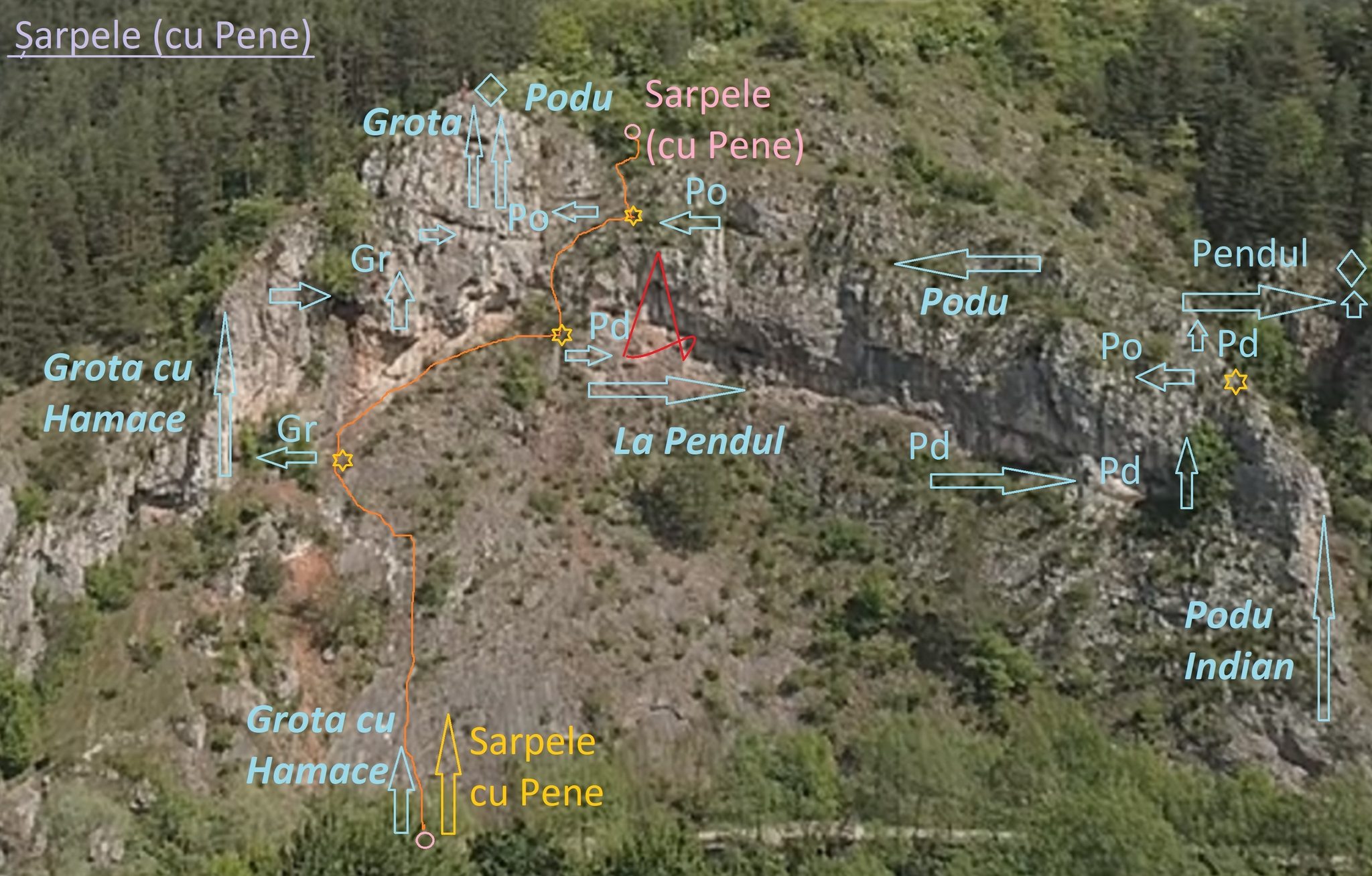
The via ferrata routes in Suncuius, Bihor, were built by Cassio Montana mountain club between 2018 and 2023, mostly with their own financial resources. Club members and volunteers helped during the process. The routes, located on the same rock face, are: 1) Grota cu Hamace (Grotto with Hammocks), 2) Podu Indian (Indian Bridge), 3) Sarpele cu Clopotei (Rattling Snake), 4) La Pendul (Pendulum), 5) Piticot (Little Dwarf would be similar in English).
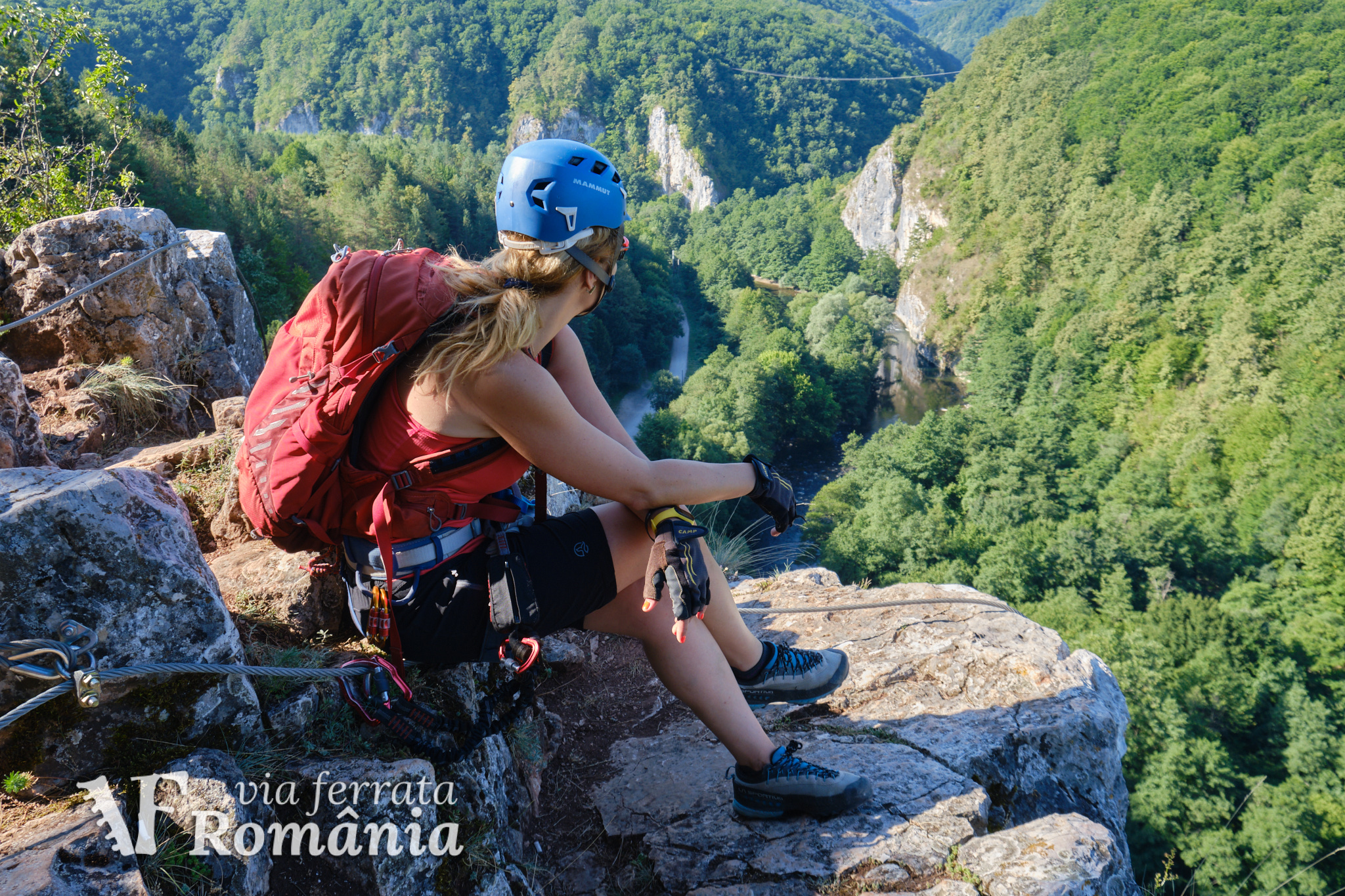
Access: By car, you can park before Gradia guesthouse, at 46°56’24.2″N 22°32’51.9″E or 46.940056,22.547750. Don’t park under the rock walls because of rockfall danger. From here you walk for about 5 minutes along Crisul Repede river, to the base of the rock called Simeonului, on your left. Along the way, you notice two guesthouses and a somewhat basic camping area on the other side of the river.
In Suncuius you can also arrive by train. From the train station to the start of the via ferrata routes you walk for 2km.
Difficulty: Grades are from A (very easy) to E (extreme).
Grota cu Hamace – described separately here
- Length 150m
- Vertical climb 80m
- Difficulty B
- GPS access / Parking 46°56’24.2″N 22°32’51.9″E or 46.940056,22.547750 (geo)
- GPS Start Via Ferrata 46°56’18.7″N 22°32’48.2″E or 46.938528,22.546722 (geo)
- Access hiking duration: 10min
- Via ferrata duration: 40min
- Return hiking duration: 15min
- Total time: 1h 05
- Inaugurated on April 28, 2018
- Open all year round, avoiding rainy days when the rock becomes slippery
According to CASSIO Montana, the route starts easy with a low angled rock face, followed by a small traverse, then up. At this point, there’s an intermediate exit available, upwards. The route continues to the right via a traverse with a cave at the end, where you can rest. In the cave, there are also 2 hammocks – remain clipped to the cable while using them! After this, you continue up with a slightly overhanging 2-3m wall, near the second intermediate exit (to the left) from the route. The main route continues with another traverse, 4-5m, and then another few meters on a vertical wall, which lead to the final exit from this route.
Both intermediate exits go up from the main cable, while the main route continues with a traverse to the right.
Podu Indian – described separately here
- Length 160m
- Vertical climb 80m
- Difficulty C/D
- GPS access / Parking 46°56’24.2″N 22°32’51.9″E or 46.940056,22.547750 (geo)
- GPS Start Via Ferrata 46°56’16.1″N 22°32’49.4″E or 46.93781,22.54706 (geo)
- Access hiking duration: 10min
- Via ferrata duration: 30min
- Return hiking duration: 15min
- Total time: 55min
- Inaugurated on September 4, 2020
- Open all year round, avoiding rainy days when the rock becomes slippery
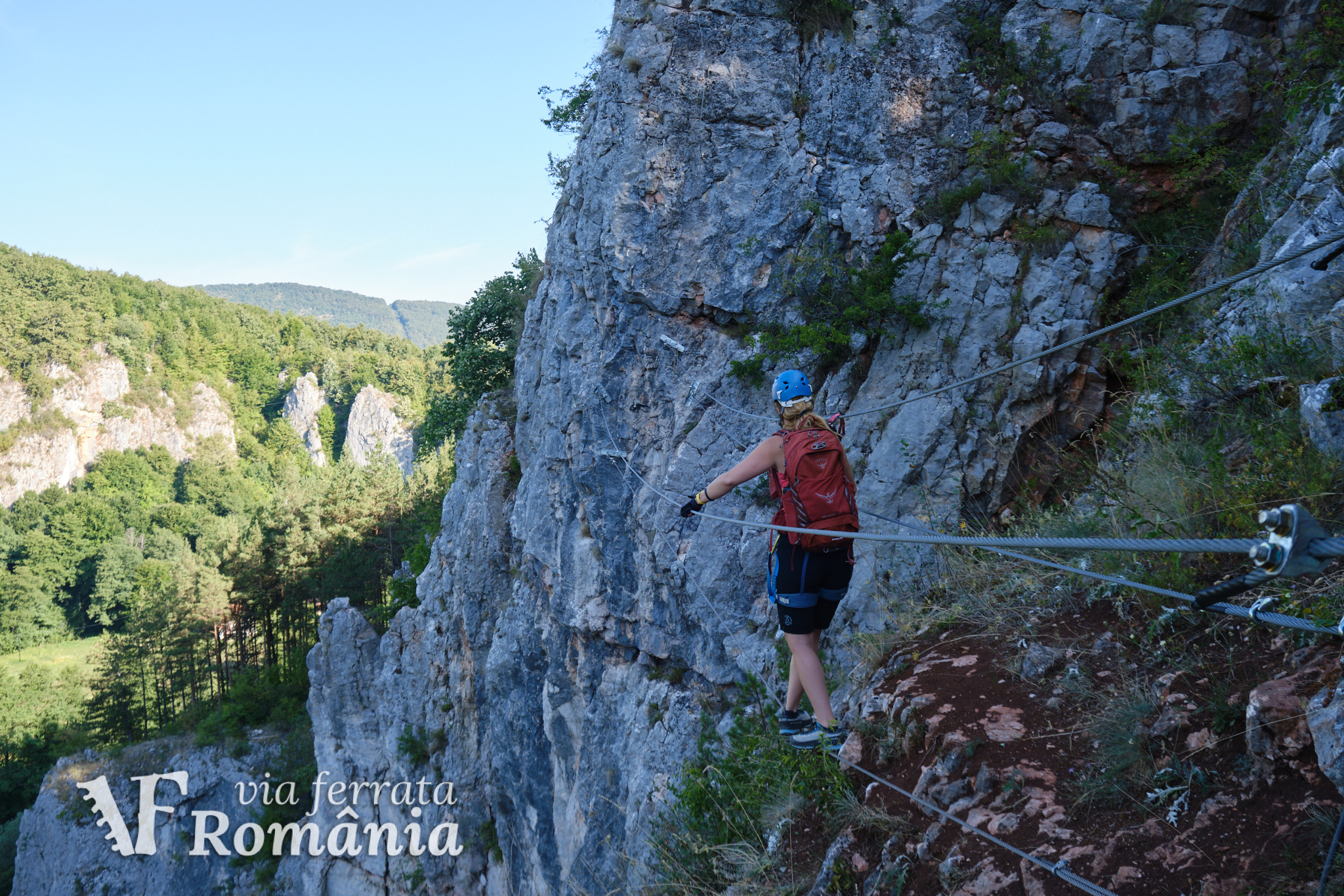
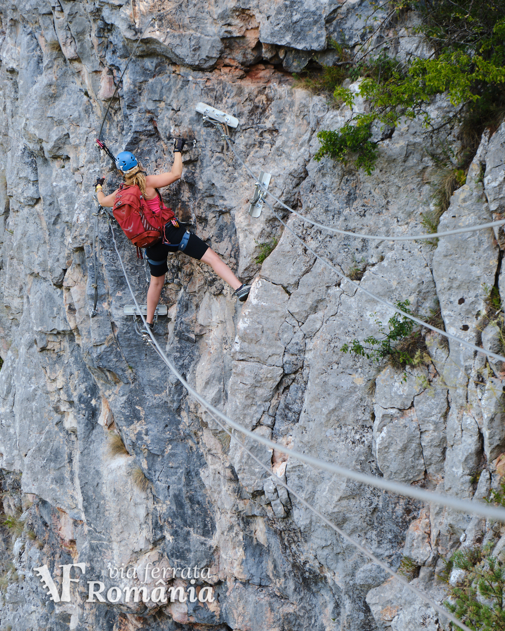
According to CASSIO Montana, the route starts with a slight overhang with no cable, it contains several exposed and technical sections, with many natural holds and very few artificial steps. There is also a long traverse and, of course, the Indian bridge.
The route requires advanced via ferrata skills. The artificial steps are spaced apart and available only when absolutely needed (like overhanging sections or sections with no natural holds). Appropriate mountain footwear with proper soles is highly recommended.


Sarpele cu Clopotei
- Vertical climb 80m
- Difficulty A/B
- GPS access / Parking 46°56’24.2″N 22°32’51.9″E or 46.940056,22.547750 (geo)
- GPS Start Via Ferrata 46°56’18.7″N 22°32’48.2″E or 46.938528,22.546722 (geo)
- Access hiking duration: 10min
- Via ferrata duration: 40min
- Return hiking duration: 15min
- Total time: 1h 05
- Inaugurated on February 11, 2023
- Open all year round, avoiding rainy days when the rock becomes slippery
Common start with Grota cu Hamace. First section is on the low angled rock face, grade A, then, at the first bifurcation of cables, we continue slightly right and up, leaving the Grota cu Hamace route to the left. We reach the pendulum section of the route Pendul and we go upwards at this point, leaving the Pendul route on our right. Going upwards we intersect the route Podu Indian at the bridge and from here there are two options: 1) continue up and exit the route or 2) go right on the traverse of Podu Indian, then up to the wooden steps bridge and finish the route La Pendul without actually swinging on the pendulum.
Sarpele cu Clopotei is actually an emergency exit from the route Pendul. Climbed on its own, it can be a good warm-up or initiation route.
La Pendul
- Vertical climb 80m
- GPS access / Parking 46°56’24.2″N 22°32’51.9″E or 46.940056,22.547750 (geo)
- Difficulty B (A according to the builders)
- GPS Start Via Ferrata 46°56’18.7″N 22°32’48.2″E or 46.938528,22.546722 (geo)
- Access hiking duration: 10min
- Via ferrata duration: 40min
- Return hiking duration: 20min
- Total time: 1h 10
- Inaugurated on August 6, 2023
- Open all year round, avoiding rainy days when the rock becomes slippery
The route starts directly from the unpaved road next to the river, common start with Grota cu Hamace and Sarpele cu Clopotei. You initially climb the low angle rock, grade A, and at the first cable bifurcation continue slightly right and up, leaving the Grota cu Hamace route to the left. We reach the section with a pendulum, where we have the exit option up on the Sarpele cu Clopotei route.
For the pendulum section, we move to the last natural rock ledge with the cable on our left for the last 2-3 meters. From there, we can grab and attach the cable of the pendulum directly to the harness. After closing the carabiner on the pendulum, we can detach the 2 via ferrata carabiners from the regular cable and clip them to the harness. We let ourselves hang in the pendulum and using our hands and feet we move on the moving ladders to the left until we catch the vertical metal handle. From this handle we push ourselves back, moving away from the rock, with as much power as possible if we want a wider swing. The pendulum will take us without any other help to the right to the next cable segment. Careful! Do not push sideways to the right. You just push yourself back away from the rock.
After the pendulum section, we continue to the right with a traverse, until we cross the vertical area of the Podul Indian route. From here we go up to the bridge with wooden steps, which we cross and then continue with the last section, through the forest, secured with 30m of cable.
Piticot
- Length 20m
- Vertical climb 16m
- Difficulty A/B
- GPS access / Parking 46°56’24.2″N 22°32’51.9″E or 46.940056,22.547750 (geo)
- GPS Start Via Ferrata 46°56’19.6″N 22°32’47.2″E or 46.938778,22.546444 (geo)
- Access hiking duration: 10min
- Via ferrata duration: 10min
- Return hiking duration: 2min
- Total time: 22min
- Inaugurated on June 1, 2018
- Open all year round, avoiding rainy days when the rock becomes slippery
The Piticot route is dedicated to children. According to CASSIO Montana, “the route is recommended for children of all ages from 1 to 14 years old. The youngest junior who climbed the route was not yet 4 years old. It was obviously a little girl because they are braver.”
The route is a combination between via ferrata and sport climbing, being a 16m high route, with metal steps and via ferrata cable. You first prepare the route for top rope climbing, just like on a regular sport climbing route. The child climbs the via ferrata and can practice moving carabiners on the steel cable, while being secured with a climbing rope and belayed from the ground.
From the top, children are lowered by rope, like in sport climbing.
You will need sport climbing experience to prepare the route for top rope, to belay the children, and to rapel at the end of the session. A minimum of 40m long rope and sport climbing equipment is needed. The carabiner on top can be used at the end of the session for the last person cleaning the route. Otherwise, use your own equipment to build the top.
Prices: free. Until the fall of 2021, access was paid.
The routes built by the CASSIO Montana club, a non-profit organization, were based on donations and volunteering. To support maintenance of the existing routes, you can contact the club directly.
Mandatory gear: alpine helmet, alpine harness, via ferrata set. Optionally, gloves.
Return trail: For Piticot, read above. For all the other routes, descent is through the woods, on a marked trail. In about 10 minutes you are back at the car park.
Wheater: Meteoblue Suncuius / Viewweather Suncuius.
Emergency calls: 0-SALVAMONT, which is actually 0725.826.668, or 112, the European all around emergency number.
Sources:
- We climbed some of the routes.
- https://www.cassiomontana.org/