B ↔ 170m ↑ 80m ⏱ 40min vf / 1h05 total
View details in Romanian.
The via ferrata route called “Grota cu Hamace” (meaning Cave with Hammocks) was opened on April 28th 2018, near Suncuius, Crisul Repede defile/gorge, in Padurea Craiului Mountains, a subunit of the Apuseni Mountains. The route was self funded and built by the CASSIO Montana club.
Summary:
- Length 170m
- Vertical climb 80m
- Difficulty B
- GPS access / Parking: 46°56’24.2″N 22°32’51.9″E or 46.940056,22.547750 (geo)
- GPS Start Via Ferrata: 46°56’18.7″N 22°32’48.2″E or 46.938528,22.546722 (geo)
- Access hiking duration: 10min
- Via ferrata duration: 40min
- Return hiking duration: 15min
- Total time: 1h 05
- Best time: May – October, except for when it’s rainy and the rocks become slippery
All via ferrata routes in Crisul Repede Defile
- Via Ferrata “Podu Indian” – Șuncuiuș, Bihor (C/D) (English) -
C/D | ↔ 160m | ↑ 80m | ⏱ 30min vf (55min total) - Via Ferrata “Grota cu Hamace” – Șuncuiuș, Bihor (B) (English) -
B | ↔ 170m | ↑ 80m | ⏱ 40min vf (1h05 total) - Via Ferrata “Casa Zmeului” – Vadu Crișului, Bihor (C) (English) -
C | ↔ 215m | ↑ 150m | ⏱ 1h vf (2h total) - Via Ferrata “Mocănița” – Peretele Zânelor, Vadu Crișului, Bihor (B) (English) -
B | ↔ 150m | ↑ 110m | ⏱ 1h+ vf (2h+ total)
Access: If arriving by car, you can park at 46°56’24.2″N 22°32’51.9″E (or 46.940056,22.547750), just before reaching Pension Gradia, or in the pension’s own parking area. Parking near the rock walls is not recommended so you can avoid possible rock falls.
From here you continue along the river up to 46°56’18.7″N 22°32’48.2″E (or 46.938528,22.546722), the starting point for the via ferrata route.
Length of via ferrata route: 170m. Vertical climb: 80m.
Difficulty: B (easy). Grades are from A (very easy) to E (extreme).
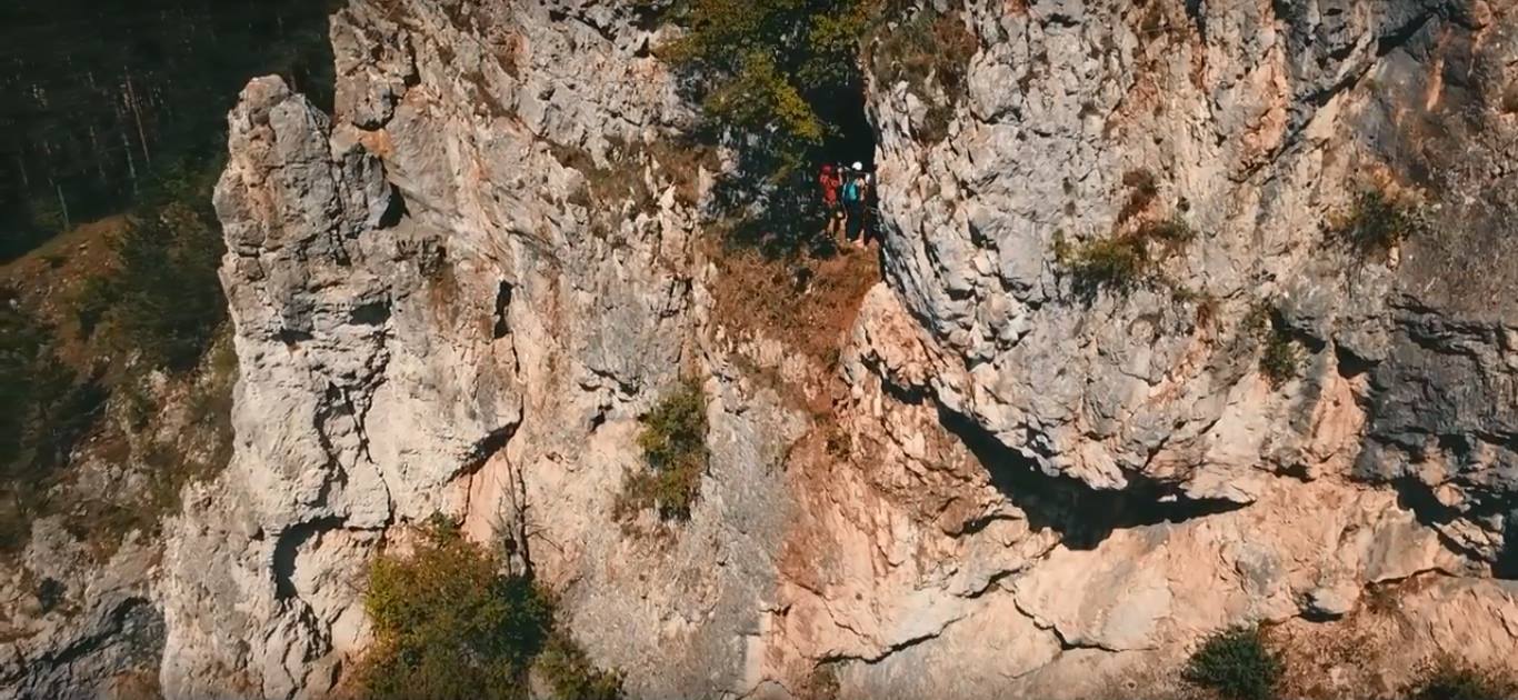
The route starts easy with a low angled rock face, followed by a small traverse, then up. At this point, there’s an intermediate exit available, upwards. The route continues to the right via a traverse with a cave at the end, where you can rest. In the cave, there are also 2 hammocks – remain clipped to the cable while using them! After this, you continue up with a slightly overhanging 2-3m wall, near the second intermediate exit (to the left) from the route. The main route continues with another traverse, 4-5m, and then another few meters on a vertical wall, which lead to the final exit from this route.
Duration for the via ferrata route: 40 minutes.
Prices: free. There used to be a fee until Autumn 2021.
The routes built by the CASSIO Montana club, a non profit organization, were based on donations and volunteers. In order to support development of future routes and maintenance of existing ones, you can make a small donation by contacting the mountain club.
Mandatory gear: alpine helmet, alpine harness, via ferrata set. Optionally, gloves.
Return trail: You can return to the starting point in about 10 minutes, by following a trail through the woods. During the route, there are two possible intermediate exits, both going up while the main route continues to the right.
Wheater: Meteoblue Suncuius / Viewweather Suncuius.
Emergency calls: +40.SALVAMONT, which is actually +40.725.826.668, or 112, the European all around emergency number. GPS coordinates for localization: 46°56’18.7″N 22°32’48.2″E or 46.938528,22.546722.
Video:
Photos:
Sources:
- We climbed this route.
- https://www.facebook.com/CassioMontanaOradea/posts/2039533642726885